Enjoy the best of the epic Laugavegur trail


The Laugavegur Hiking Trail is Iceland’s most famous hiking trail. National Geographic has described the trail as one of the world’s most beautiful treks and a must-do for all hiking enthusiasts.
If you are an avid hiker in great shape, the Laugavegur trek can be easily done in two days with a light backpack by staying in mountain huts along the trail.
Tour overview
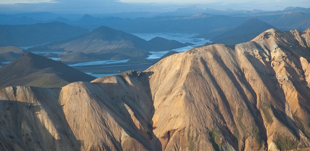
The trail connects the Landmannalaugar and Þórsmörk Nature Reserves and offers a variety of different volcanic landscapes along the way. Every day has different views with beautiful scenery of pristine nature with volcanoes, lava fields, glaciers, natural hot springs, black arctic deserts and lush forested valleys.
For a detailed description please read our free Laugavegur Volcano Trail Online Guide
This self-guided 2-day hiking package physically demanding and is ideal for trail running, mountain biking and fast-paced hiking.
As accommodation and meals are provided you only need to carry food for first day and extra clothing. Other meals and bed linen is provided.
It includes bus tickets to and from the trail, accommodation in mountain huts in addition to meals on the last day in Þórsmörk. It also gives you an extra day to enjoy trails in Þórsmörk or to head on over the 30-kilometre long Fimmvörðuháls Volcano Trail to Skógar.
Accommodation along the way is provided in mountain huts and on camping grounds. We start the trek in Landmannalaugar and finish at the Volcano Huts in Þórsmörk or you can extend the trek by one or two days all the way to Skógar, south of the Eyjafjallajökull Volcano and Glacier.

You start the tour from the BSI coach station in Reykjavik, from whence the mountain bus will take you to Landmannalaugar.
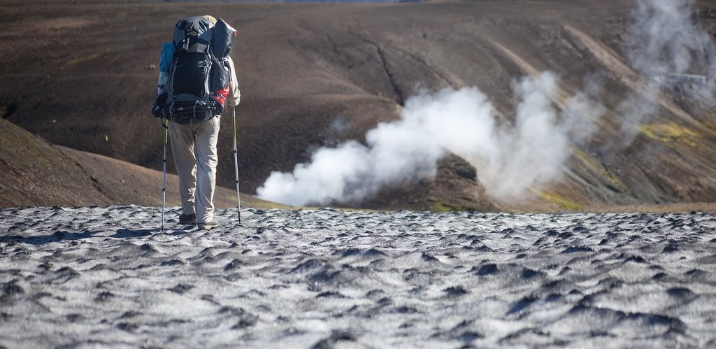
Starting the trek from Landmannalaugar brings you to an easy hike through the lava field of Laugahraun towards the colourful mountain Brennisteinsalda. There you start a gradual climb through dissected hills with views of an incredible spectrum of colors. After 3 – 4 hours you should arrive at the Stórihver geothermal area and hot springs. About 2/3 of the way is likely to be covered with snow until late summer. At an elevation of around 1000 metres you can expect fog to show up suddenly and without warning. The trail is clearly marked but hikers must be careful not to loose the track in poor visibility. Hrafntinnusker Hut (Höskuldsskáli) will appear suddenly about 2 km past a memorial of a traveler, who sadly died of hypothermia in this area in June 2004. Heading out from the Hrafntinnusker hut the trail takes you through a valley with small ravines that sometimes may be filled with snow. A short and steep incline leads you to the highpoint of today’s walk.
If the visibility is good, a side trip to the summit of mountain Háskerðingur (1.281 m) will reward you with a breathtaking view. This is best done from the western slope of the mountain. But take care as you have to cross a glacier on the way. Ask the hut warden in Hrafntinnusker for further information. Soon after you will leave the colorful rhyolite mountains and enter an area with contrast of dark palagonite mountains and white glaciers. You will also notice a considerable increase in vegetation. The trail down the Jökultungur is quite steep and care must be taken during the descent. The last few kilometers to the huts by the lake Álftavatn are on flat land. You will be staying in the mobile trucks situated by the small restaurant hut.
The trail leads you over the Brattháls Ridge into Hvanngil Ravine, wading across the small Bratthálskvísl River. In the Hvanngil Ravine, you will find two huts, one built for sheepherders in 1963 and one for tourists, built in 1995. As Álftavatn and Hvanngil are only 5 km apart, Hvanngil can be used as an alternative accommodation. The huts have toilet facilities, showers and a small camping site in an old lava field.
Leaving Hvanngil you cross a bridge over the Kaldaklofskvísl River. On the eastern bank of Kaldaklofskvísl River, the trail splits in two. You should take the path leading south to Emstrur and Þórsmörk. The other branch leads east to Mælifellssandur (Road F 210). Soon after that, another river has to be waded. For a few kilometres, the Laugavegur Trail joins a mountain road. You can stay on the road all the way to the Emstrur hut or take a hiking trail alongside the road. You will have to cross the powerful Nyrðri Emstruá River on a bridge that the road will take you to. After crossing the bridge you will traverse a few kilometres on flat land until you suddenly find the Botnar huts in Emstrur.
From Emstrur, in about 45 minutes, after heading out from the Emstrur huts you should be on a steep path leading towards the canyon of Syðri-Emstruá River. The river can be crossed on a hiking bridge in a narrow part of the canyon, with the river raging beneath your feet. From the canyon, you will be walking through a hilly area known as Almenningar with the first view of Þórsmörk insight. At the end of Almenningar, you will have to wade the Þröngá River the deepest on the Laugavegur Trail. When wading it is good practice to go hand in hand and head downstream or to use hiking poles to keep your balance. After crossing the Þröngá River you will enter the forested area of Þórsmörk.
Follow the path to an intersection with signs that show directions to different huts in Þórsmörk. From there you should reach the Volcano Huts in Húsadalur Þórsmörk or Langidalur hut in 30 minutes. You have dinner included at the Volcano Huts this evening, and we recommend as well that you visit the warm natural pool and sauna, which are right next to the huts. Evening walks: In Þórsmörk you will find many possibilities for evening walks such as onto the Mt. Valahnúkur or to the Sönghellir Cave.
Select between heading back to Reykjavik, staying in Þórsmörk or trekking the Fimmvörðuháls trail to Skógar:
Three options are available on the last day of this program.
Adding an extra night in Þórsmörk gives you the possibility to stay in Þórsmörk for a day and then completing the Fimmvörðuháls trail on the fourth day. An extra night is available in the booking process of this experience as an Extra.
Volcano Huts have now opened up a new restaurant by the Álftavatn camp on the Laugavegur Hiking Trail. The restaurant is the second camp on the trail about 24 kilometres from Landmannalaugar.
The Álftavatn Restaurant is open daily from 7 am - 11 pm and serves breakfast, lunch, dinner, snacks and drinks at the bar.
Must have:
Nice to have:
Please Note: Carry a map & compass and/or a GPS – know how to use it!